My Pyrenees HRP Diary - Introduction

This blog was begun in 2015, to record my walk along the Pyrenees HRP from Hendaye to Banyuls. If you want to read about that, I suggest you start here.

But that is all in the past now, and I have expanded the blog a little to cover more recent events.. such as:

Pennine Way 2024
Snowdonia Way 2017
Hebden Bridge 2015
Equipment Reviews
North Downs Way 2017
Pennine Way 2019

I hope you will find something interesting. Please do provide a little feedback or comment, and if you are interested in something that I didn't say enough about, please let me know .. happy walking! For posts not about walking, click on "View my complete profile," below right.
Jerry

Tuesday, 16 June 2015

Hebden bridge update day 5 - Pendle Hill's Big End

Today I drove to Pendle in Lancashire to climb Pendle Hill. It's only about 18 miles - England's much narrower up here. At 557m (1830ft) it is an impressive lump, bigger than anything around hebden bridge. There are some intriguing names. . the summit, where the trig point is, is called the Big End. And below, as it were, is a hamlet called "Buttock." Really. 

Since the hill is effectively stand - alone, and surrounded by industrial towns like Burnley, Colne, Blackburn etc, it is quite a popular place and I saw a number of people. The weather was kind, and, sunny and not windy even on top. There are really spectacular views all around, with the lake district to North and west, and the pennines to the east. 

 It is quite a stiff climb and ploughing up the steep hill in t shirt and sunglasses, it felt very Pyreneesy. I managed the climb quite well, so I think this little excursion has been worthwhile. I am learning to cope with this stupid little keyboard too. .

Back home tomorrow and prepare in earnest for the Linton Cream Teas. . I will do another post next week about final preparations, if I get time. 

View from the summit, looking back at the South Pennines. Some clever person has painted the trig point in the colours of Burnley FC. 
This big lump is not Pendle but the Moor next door, Spencer Moor. That footpath looks challenging
A boundary stone near the summit
Upper Ogden reservoir, which is fed by Ogden Clough, sounds like someone out of coronation street

Monday, 15 June 2015

Hebden Bridge Update day 4 - The Great Wolf Stones

In some ways, a walk similar to yesterday's: up on the roof of England, nobody else in sight, fantastic views and decent weather. The Great Wolf Stones are a prominent landmark and having passed quite near them twice on the Pennine Way, it was nice to see them close to today. The views from there are tremendous, all the way around.

Wildlife update. . As you might expect large wild animals are few & far between,  though some of the cattle can be quite frisky. But I have seen lots of rabbits, several hares, a small thing that might have been a weasel or a stoat, a few deer, and lots of unfamiliar birds such as curlews, lapwings, and grouse. The grouse are impossible to spot in the heather, they wait until you are about to step on them before panicking and racing off, while you leap back, as startled as they are.
My favourites though are the curlews, they have such a recognisable and evocative call.

Tomorrow, thinking about climbing Pendle Hill

So difficult to capture the sheer scale and beauty of the views around here. Nor the ubiquitous Pennine Way paving stones 
Lots of boundary markers hereabouts! This one is called "Old Bess"
Another selfie at the Wolf Stone trig point. The Wolf Stones and Watersheddles reservoir visible in the background.  
Lots of important footpaths here. . Pennine Way, Bronte Way, Calderdale way, millennium way   

Sunday, 14 June 2015

Hebden Bridge Update - day 3: A magical day

I came to hebden bridge to do lots of what I can't do in Kent, ie climb big hills. So the first thing I did when I got here was to look over the maps for the highest spot around, and that is Lad Law. It is 517m  (not 507 as I said yesterday) or 1700ft.

According to the maps there is only one path to the summit, on the far side from here and too far to walk so I set off in the car to have a look. .  after a while I came to the Widdup reservoir, it is a very scenic spot with a nice car park attached so I stopped there and looked at the map.. not too far from Lad Law, seemed doable, so I set off.

To cut a long day short, I had a wonderful time wandering over the moors, sometimes a path and sometimes not, but always on the roof of England, with amazing views and hardly any other people. I stopped by some rocks and cooked a gourmet meal  (heat water, add some rice and a stock cube). As I was doing so a man came past wearing a mac and ordinary shoes; he said he came here twice a week but as it was raining he was going back now. . but it wasn't raining. . surreal. No wonder we need mountain rescue teams. I didn't see anyone else.

In the end I walked only about 8 miles, but it is hard going through the heather and peat bogs, finding your own route, and it felt like a lot more. But altogether it was a lovely day, perhaps the photos will explain why better than I can!

Widdup reservoir
In the distance, Lad Law
The Dove Stones.  Well, some of them. .
Phone camera not really doing justice to these wide views. .

Ready to cook. .The stove at front right (it weighs 8gm ) cooking pot and windshield behind, rice, spork and pot cosy to the left. Well under 1/2 lb all told.
A selfie on top of lad law, clinging to OS trig point

Saturday, 13 June 2015

Hebden Bridge Update day 2: Back on the Pennine Way!

Only a short update today as I'm a bit tired. . It has been quite wet here today. It was forecast, so no great surprise, and it did stop by about 1pm or so. Dry since, and muggy, there is talk of a thunderstorm overnight. Which would be the best time for it. .

I had a long walk today. First of all down the hill then up the far side of the valley to Stoodley Pike, about 5 miles. Then I followed the Pennine way back down to the main road a mile or so outside HB, and up the far side as far as the Pack Horse Inn above Gorple reservoir, another six miles or so. Then back to HB via Walsham and Hardcastle Crags, the evocatively named National Trust beauty spot. Altogether, 16.6 miles and over 1000m climb so an early night beckons. Tomorrow, the highest spot hereabouts, Lad Law at 507m or 1660ft


Should be possible to see Stoodley Pike monument, through the gloom. .

When you get near, it is big! There is a staircase inside and you can climb up to the balcony. 
Back on the Pennine Way..
Friendly chicken at the Pack Horse Inn. Note improved weather. .
Still got bluebells up north! 
Stepping stones over the river Calder at Hardcastle Crags. Stepping stones cannot be resisted. .

Sunday, 7 June 2015

Hebden Bridge Update - Day 1: Heptonstall graves

Here I am in Hebden Bridge, after an uneventful drive up the A1 from Kent. I am here for 5 days and will be doing an update each night using my phone, to see what problems there might be. . So I expect there will be typos and layout problems galore.

I am staying at the Thorncliffe B & B and very comfortable it is too. Run by two ladies, very friendly.

Having settled in I set out to walk up to Heptonstall, only a three mile round trip, but with plenty of uphill - it is hardly possible to go anywhere in these parts that hasn't. This must be the hilliest town in England. Heptonstall has a number of unusual features,  including two churches side by side, one now a ruin. Between them they have more gravestones than I have ever seen in one place. . Seven centuries worth, in a place that clearly wasn't all that keen on cremations.  Row upon row, with others laid flat and acting as flagstones.

The weather has been fine today, warm & sunny, but rain is forecast for tomorrow. Ah well, what will be will be. I have a longish walk planned, c 16 miles and the computer says, more than 1050m of ascent, which is pretty much up to pyrenees standards.

Old church and graveyard, Heptonstall 
One of the better - known inmates,  Sylvia Plath 
A view across Calderdale. Stoodley Pike obelisk can be seen in the distance. Close up, to come tomorrow!

Friday, 5 June 2015

27 Days to departure! More Logistics...

So, less than a month to departure and I'm sorry to say that I have not made nearly enough progress. The walking preparation itself is going well.. the two three-day walks satisfactorily completed, and I am booked into accommodation in Hebden Bridge for a week from next Friday.

Hebden Bridge is a nice town a few miles from Haworth and the Pennine Way goes past it. It is nothing if not a hilly area, and I am hoping that when I come back I shall be able to motor up hills - as is something of a requirement, in the Pyrenees.

One other thing I shall be doing in Hebden Bridge is to provide daily updates to this blog, via my Samsung Galaxy 5 phone, hopefully with photos, just to see that it is do-able and all working properly..

I am pretty much happy with my gear now, tried and tested on the two three day walks and my previous trips, for example on the Pennine Way last year. I have bought a new smartphone and an external battery that will keep it charged for a week or more. I need that not just for internet updates (and even the odd phone call?) but because this time, all of my maps will be on it, I will go completely paperless apart I think from the Joosten HRP Guide which I must either take or scan into a Word document. Or buy the Kindle edition, which at £12.23 seems steep, but is still better than 320 scans!

One side effect of this is that the phone becomes a vital piece of kit. To the point where I think I might have to take the old s3 phone as backup. Losing the phone or having it just stop working would leave me with no map or guidebook as well as no gps location .. or even phone calls!

Beyond that, little has been done. I still have to book the train tickets and any accommodation needs, and that is my top priority now, I will do that this week. The other high priority is route planning. I need an outline for the trip day by day.. it is not necessary to adhere to it, but the outline must be there because as all chess players know, a bad plan is much better than no plan at all; a bad plan can always be improved but with no plan, you just flounder. I will take my laptop and maps to Hebden Bridge, and hope to work on them in the evenings and come back with a completed outline..


July in the Pyrenees,
2013. I hope not to
have so much snow
this year; but I must cope with what I am given
 The Cirque du Lescun, part of the High Pyrenees... 2013, hence all the snow


Friends.. even though I set off and walk on my own, and the Pyrenees is not a busy part of the world, it is surprising how many people you meet and talk to.. and have things in common with. Arne (on the right) and John at the back are friends I am still in touch with. Trying to remember where this was.. Lescun maybe


Monday, 6 April 2015

84 Days to departure! Logistics...

A Hunters Cabin near the Col d'Ibardin, where I spent my first night in the Pyrenees in 2010 (that's my tent and rucksack). It had a water source, a barbecue, and several other walkers...

I don't like planning walks; really I just want to set off and get started. But some planning is unavoidable. This post should provide a checklist of the minimum that needs to be done...

First of all I must set dates. Not just for departure, but for preparation and training too - the High Pyrenees is a demanding environment. So here we go:
         
3 day prep walk:              27/28/29 April
3 day prep walk:              13/14/15 May                                          
6 day prep walk:              12/17 June
Depart for Hendaye:         Monday 29 June
Start walking:                  Tuesday 30 June
Finish at Banyuls :            Wednesday 18 August (50 days later)
Home:                            Friday 20 August

The preparation walks are partly for physical training - I will be trying to do 20 miles/day or thereabouts - and also to check out all my gear. I will try to use all the stuff I am going to take to the Pyrenees. Also do some blog updates etc. from my phone.

I've allowed 50 days for the walk itself, but the truth is I have very little idea how long it will take. If I'm feeling fit and press on, I reckon I might walk the 500 miles in no more than 30 days - that is only 16 miles/day after all. However (a) it does go up and down a lot - and this seriously affects how far you can walk in a day. (b) I expect to have a rest now and then. I expect to have three or four "zero days," as required. And also (c) I would like to climb a couple or three of the higher peaks en route: Vignemale, Posets, Aneto.. for example. More about this when I get onto planning the route. The rest of the time is just contingency - it will stop me worrying about running short of time.

The other aspects of logistics planning I need to sort out are:

- booking travel, to and from
- booking accommodation as necessary (only the first day or two probably)
- communications: phones and phone tariffs, blogging etc.

Rather than try to detail those now I will post this update, and then come back and add to it over the next week or so.

Once that is done, the next update should deal with route planning.. or will panic have started to set in?

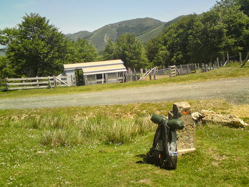
This was supposed to be a small shop, near the Redoute de Lindux. It was firmly closed. Shopping is a tricky business on the HRP. My rucksack is leaning against a stone marking the French/Spanish border


The pilgrims' dormitory in Roncesvalles, 2010. It accommodated 250 people in some discomfort and staying there was quite an experience; but it has since been replaced by a new building