My Pyrenees HRP Diary - Introduction

This blog was begun in 2015, to record my walk along the Pyrenees HRP from Hendaye to Banyuls. If you want to read about that, I suggest you start here.

But that is all in the past now, and I have expanded the blog a little to cover more recent events.. such as:

Snowdonia Way 2017
Hebden Bridge 2015
Equipment Reviews
North Downs Way 2017
Pennine Way 2019

I hope you will find something interesting. Please do provide a little feedback or comment, and if you are interested in something that I didn't say enough about, please let me know .. happy walking!


Jerry

Sunday 4 October 2020

Edale 2020, Day 5

 Thursday 17 Sept

16,546 steps, 8.25 miles

Wayne had to go back home on Wednesday evening, but I had one more day in Edale. After a look at the map, I decided to drive over to Ladybower reservoir, and walk up to Alport Castles. As you will see, Ladybower is a very scenic area. Alport Castles are just grassy mounds, except for The Tower which is .. well, more of a tower, really.


Setting off from the car park. Lots of vistas and glimpses of the reservoirs ...

.. but nothing like this, which I had to borrow from Pinterest. Right at the left is the edge of the Kinder Plateau. The big lump in the middle is the ridge I walked along to get to Alport Castles, which can't yet be seen.


Up on the ridge now. To the left is the Snake Pass, with Kinder Plateau beyond
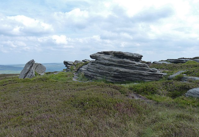
Alport Castles

The Tower

It is quite steep to climb...

But evidently it can be done! I didn't try, but next time, maybe..

On the way back down now

The Cheshire Cheese, between Hope and Edale, highly recommended

On the next morning, it will be time to drive back home so this brings my little stay in the High Peak district to its end. Nearly always, I go walking on my own; so being with Wayne this week was quite a departure for me, and very pleasant it was, too. I expect I will still carry on hiking alone, but Wayne is an excellent walking companion, and I will very happily do this again some time in the future. Thank you, Wayne. I put on over a kilo this week, but with all the walking we did, I just can't think why...

I should also mention that Wayne is a demon with the GoPro camera. He has done lots of videos, each one better than the last.  You can see them here, including two that were taken during this week. If you subscribe to his Trek Mate channel, he will hopefully become rich and famous..

As for the Peak District, there is no better walking area that is nearer to Kent. And not many anywhere.. I don't think I really was able to convey just what a magical place the Kinder Plateau can be. Edale is a cheerful, busy tourist resort, like many places in Derbyshire. But once up on the plateau and away from the main routes, it becomes a haven of peace and calm amidst a very unusual and different environment. Not perhaps to everyone's taste, what with all the bogs and heather, but I love it. I will go back again, I don't think we ever did find that elusive Kinder Summit ..


Edale 2020, Day 4

Wednesday 16 September 2020

12.7 miles, 25,535 steps


Having spent two days up on the Kinder Plateau, we thought it would be sensible to go the other way today. So we plotted a route South, up to Mam Tor, over the far side and down towards Castleton. There are seven pubs, in Castleton ... 

From there we found a different route back up to Hollins Cross, Back Tor and Lose Hill before returning back down into Edale. So we climbed up the dale side twice, for another reasonably energetic day with over 2,000ft of climb. The weather was again good, but cooler and more cloudy today, so visibility and therefore photographic opportunities were a bit more restricted:


Somewhere below Mam Tor, to give you an idea of the visibility during the morning ..

This is Cave Dale, the end of the Limestone Way that leads down into Castleton. Peveril Castle is visible in the distance

Getting closer to the castle..

We are deep in limestone country, and Castleton's caverns and caves are famous. This is the entrance to Peak Cavern. The sign refers to "The Devil's Arse"


On the way back towards the ridge above Edale now. Still cloudy!

We clambered up and arrived at the ridge near Back Tor, which is in the background. Heaven knows what I was pointing at, our B&B perhaps..

The climb up to the top of Back Tor is short, but very steep. Hard to convey, in a photo!

But you do get good views from the ridge. This is looking along to our next destination, Lose Hill

At the summit of Lose Hill there is a panorama listing all the things we ought to have been able to see, but mostly couldn't :-)

Starting back down now from Hollins Cross, towards Edale

We didn't really want to go to the pub, for the second time that day .. but Nicola was coming to pick Wayne up in the evening, and we arranged to meet her in the Nag's Head..


It was another good day's walking, and Castleton is a lovely little town - it seemed to be all pubs and outdoor shops, so definitely my kind of place! I forgot to take any photos while we were there, so here is a stock photo of the High St with Ye Olde Cheshire Cheese, which serves very nice beer :-)


Saturday 3 October 2020

Edale 2020, Day 3

Tuesday 15 September 2020

13.6 miles, 27,348 steps

Once again, the weather was amazing, and in fact continued to be so all week. The plan for today was to go back up to the plateau again, and then to go looking for the elusive Kinder Summit, and then on to Kinder Downfall, returning to Edale via Jacob's Ladder and the current Pennine Way. And so we did, but it did make for a longish day - still less than 14 miles, but wandering over the plateau is quite hard work, picking your way around the boggy bits (if lucky :-) and through the bracken and heather.

Still we managed it OK, (but - did we really find the Kinder Summit?) and the photos below tell the tale.

First I wanted to show you this .. it is a still from a video Wayne "Hitchcock" Boothman took yesterday, as we clambered down towards Grindsbrook Clough. The barn owl I mentioned can be seen flying away, a bit to my left.

Back to today .. this is Grindsbrook Knoll. Wayne has decided he wants to stand on the rock in the centre of the picture, for a photo. I am positioned to take the photo, but actually I am rehearsing what best to say to Nicola, after he has plummeted down into the valley ..

The rock, and the gap to the hillside, are bigger than they look          

Wayne is even more sensible than he looks .. so this pose will have to do!


After Grinsbrook Knoll we head off over the Plateau in search of Kinder Summit. There are few paths and plenty of bogs. here I am trying to extricate my walking pole, and myself, from one ..

Eventually we find what my GPS claims is the summit. It is very underwhelming, and Wayne is not impressed...

.. but I now believe that was not Kinder Summit at all, but Crowden Head. A mere 632m high, when the summit is 636. That 4m makes all the difference and I may have to go back and try again, one day. 

After summiting, or not, we flounder along and eventually find the river Kinder, and the path that runs alongside it to reach the Kinder Downfall. The Downfall is a waterfall that can be quite impressive at times, as when it is windy the water actually blows right back up, and makes a cloud. On the last day of my third Pennine Way last year, 2019, which I did from North to South, the weather was foul and when I saw the waterfall it was doing exactly that. Unfortunately it wasn't really possible to take a photo at the time! I was having trouble just staying upright in the wind, and the rain was driving into my face. All I could think of was reaching the Nag's Head!

Today was very, very different. No wind, plenty of sun and a very quiet waterfall ..

Much easier to find a nice rock to pose on, at Kinder Downfall ..

Wayne is making a video. He has decided to do a bit of "Parcouring." The view thereabouts is fine .. That is Kinder Reservoir, in the background. The waterfall itself was just a trickle, in the gap on the right. You can see the resulting video, and several other videos Wayne has done, here .. do have a look, he is good

From the Downfall we followed the modern Pennine Way back to Jacob's Ladder and then on to Edale. It is a busy path...

Clearly we are not the first to see this rock's resemblance to a monster's head..

A temptation that no clinical dental technician could resist ..

The path winds down round the shoulder ahead, towards Jacob's Ladder and the dale beyond

The top of Jacob's Ladder

After the wonders of the Plateau, the last mile or two back to Edale are rather dull by comparison

.. but this time we went to The Rambler, Edale's other pub, which was just as welcoming (and sold much the same beer and food, being under the same ownership as the Nag's Head)


Friday 2 October 2020

Edale 2020, Day 2


Monday 14 September 2020

7.6 miles, 15,232 steps

Up fairly early the next morning and set off for Edale, arriving around 9.30am. I was booked in to the Ollerbrook Barn B&B, and they had very kindly found a room for Wayne as well.  Theresa was there to welcome us, cheerful as always. Ollerbrook barn is a traditional Peak district farmhouse, not unduly chic perhaps but comfortable and welcoming. Warmly recommended.

It was still early so we left the stuff in the car and set off, straight up the hill towards the Kinder plateau. Wayne has spent much more time in the area than I have, living so close as he does, but mostly on the other side of the Edale valley, around Mam Tor and over to Castleton, so he was keen to explore the Plateau area more.

We walked up the footpath that goes up from Ollerbrook to Ringing Roger, a limestone outcrop and a bit of a local landmark. 

This is the view that greets you, as you get near to Edale. The little round lump on the front of the plateau, half left of centre, is Ringing Roger.

It is quite a stiff climb up to Ringing Roger, and then a bit of easy scramble to get to the top. The views however are fine. Once we had had a look and a rest, we had a gentle walk around the plateau to a few of the local landmarks... I will let the photos below tell the story. it was a lovely day, with beautiful warm, sunny weather; and the Kinder plateau is always a special place, full of interest. It is not huge, roughly a square perhaps four miles on a side, but in the middle it is quite wild. I don't quite know how to describe it, you have to go there. So many rush past it on the Pennine Way without really noticing it, but it is a proper haven of calm, peace and remote tranquillity. You can easily get quite lost there, so make sure your navigational skills, or at least your GPS, are well tuned. Not many ever get to see Kinder Summit..

On the way back, the plan was to go to the top of Grindsbrook Clough and then follow the old, original Pennine Way back down the Clough to Edale and the Nag's Head. In the event, once we got close to the Clough it seemed easier to head straight down the hillside to it, and so we did. On the way we disturbed a barn owl, sitting in the only tree around there, and then found a small spring with lovely cool water that we used to fill our bottles. Then on to the Nag's Head, and back to Ollerbrook.

Wayne, on the footpath up towards Ringing Roger..

Wayne is scrambling up to the top of Ringing Roger ..

Grindsbrook, seen from ringing Roger. On the way back we found our way below the rock outcrop on the right, down into the valley. No footpaths, just lots of heather and bracken!

First stop, the trig point on the plateau above the Oller Brook...

Next stop, the remains of a Halifax bomber that crashed on the plateau in 1943, one of more than a dozen aircraft crash sites in the area

.. then on to the Druid's Stone. Win Hill and the Hope Valley, in the background

Then, on to the Madwoman's stones. I sadly failed to photograph the stones themselves, but this is a line of sheep viewed whilst actually sitting on them. Behind is the Derwent Valley, with Ladybower reservoir and the Snake Pass. Fun fact: The Snake Pass is unusual in being named after the Snake Inn which is on it, rather than vice versa


Madwoman's Stones
A stock photograph of the Madwoman's Stones. Why they are so named, nobody knows..


This red grouse refused to fly off when we walked past, but instead stood her ground and shouted rude things at us. I think she must have been protecting her nest


On the way back towards Grindsbrook this hang glider flew backwards and forwards right over our heads, only a few feet up.

Ploughing down the hillside towards Grindsbrook Clough


Finally, the Old Nag's Head, open all day and coping bravely with coronavirus